
 Posted by

We have in LO.7 Geology G10
First: the Concepts
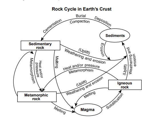
A) The rock cycle is a group of processes that act on the different types of rocks and change rocks
from one form to another over geologic time.
B) Rock composition and texture provides evidence that can be interpreted to yield a geologic
history.
C) Most of the current surface rocks of Egypt record sedimentary deposition, but there is also
evidence of igneous and metamorphic processes in the past.
Second: the References
Earth comm: Ch.3 sec.5
Third: the Videos links
Fourth: Skills
A. Interpreting rock types and textures in terms of the rock cycle.
B. Integrating interpretations of process into a geologic history.
C. Interpreting cross sections to study the age relationships of different rock units.
D. Interpreting different geological maps that show outcrops of different rocks of Egypt.
Fifth: the materials as PPT., DOCX., and PDF
In the Drive from this link
Few Notes:
What Are Rock Units?
In the Investigate, you compared large areas of similar rock types in Georgia and Alabama. The number of different rock types in Earth’s crust is enormous. However, if you examine exposed bedrock on Earth’s land surface, you would find that the rocks are generally about the same type over large areas. You might walk for hundreds or thousands of meters, or even for tens of kilometers, and find about the same rock type. This is because rocks, whether sedimentary, igneous, or metamorphic, are originally formed in large volumes by a specific process. The rock bodies that are formed during the same process are called rock units. When geologists work in the field, they try to recognize or identify such rock units. The change from one rock unit to another is usually abrupt. It occurs across some surface or narrow zone of change. This surface or zone is called a contact. It is what geologists plot on their geologic maps. You saw many examples of contacts between rock units in the Investigate. Rock units vary greatly in their size and shape. The size and shape depend on the processes that form them.
Sedimentary Rock Units
Early geologists believed that sediments were laid down in uniform sheets over large areas of Earth. This concept is referred to as “layer cake” geology. Geologists now understand that at any given time, different kinds of sediments are deposited in different places. At times, these deposits are very close together. Different sedimentary rock units can be exposed in the same area of the land surface. They might consist of conglomerate, sandstone, shale, or limestone. However, just because they represent different rock units, you should not assume that they are all of different ages. In many places, such units can be of the same age. They were deposited in different environments at the same time. As you saw in the cross section, sedimentary rock units usually have a “width” (lateral extent) that is much greater than their thickness. They typically range in thickness from tens of meters to thousands of meters. Their lateral extent can be hundreds of kilometers. Sedimentary rock units have two part names. The first part is the name of some place like a town, river, or mountain where the unit is found. The second part is the name of a rock type, or just the word “Formation.”
Igneous Rock Units
you read that igneous rocks are formed in two ways. The first way is by cooling and crystallization of magma below Earth’s surface. This is the way intrusive igneous rocks are formed. The second way is by volcanic activity. This involves extrusion of lava, or explosive eruption of pyroclastic material. Intrusive igneous rock units vary greatly in size and shape. Their size and shape depends on how the magma was put in place in the surrounding rock. Sills are sheets of igneous rock that intruded along layers of sedimentary rocks. Dikes are sheets of igneous rock intruded along fractures that cut through any existing rock. Batholiths are large masses of intrusive igneous rock with irregular shapes. Units
of intrusive igneous rocks can be seen today because the land surface has slowly been worn down by weathering and erosion As a result, the once deeply buried igneous rock body is exposed. Volcanic igneous rock units are very much like sedimentary rock units in their size and shape. This is because they are also spread over the land surface in broad layers. Igneous rock units are given names in much the same way as sedimentary rock units.
Metamorphic Rock Units
As you read in Section 4, any rock can be metamorphosed. Therefore, metamorphic rock units vary greatly in their makeup. Their shapes are more complex than those of sedimentary and igneous rock units. The reason is that metamorphism is usually accompanied by large-scale changes in the shape of the rock units. These changes take place by processes like folding and faulting. You will learn about folding and faulting in the next section. Metamorphic rock units are usually named in the same way as sedimentary and igneous rock units. In some areas, sedimentary or igneous rock units change slowly into metamorphic rock units. This is because the intensity of metamorphism usually changes slowly from place to place. You should not be surprised if you see these slow changes on a geologic map. In one place on the map you might see a rock unit called Smithtown Limestown. Then it changes gradually to Smithtown Marble in another area of the map.
We are glad for you to utilize our site. We furnish you with the assistance of introducing information to you as Egypt's extraordinary understudies in STEM Schools. This assistance is given from the data of master instructors and contemporary extraordinary understudies, and you can likewise help us in that by sharing your data, whatever it is through the WhatsApp and Telegram groups, which will You can discover them on the Home page of the site.💪Good Luck

comment 0 Comments
more_vert